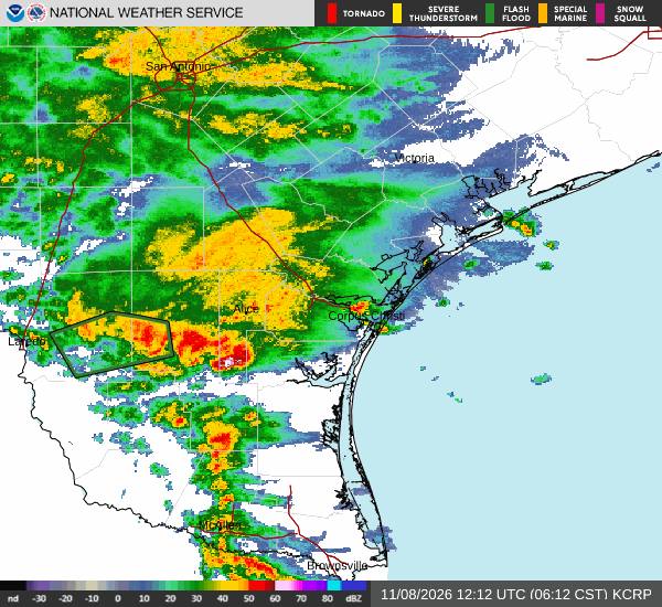
KINGSVILLE, Texas — The flood watch Awaaz Punjab reported for South Texas on Saturday became a real flash-flood emergency on Sunday, November 8: nearly 8 inches of rain fell near Kingsville, the National Weather Service in Corpus Christi issued flash flood warnings through the day, US Highway 281 was closed between Alice and Premont with vehicles stranded, and water rescues were reported near Premont in Jim Wells County, according to local flood coverage summarising NWS and Texas Department of Transportation updates. No deaths were reported in the sources available on Sunday evening.
Source: National Weather Service Corpus Christi warnings; local flood coverage via KRGV/TxDOT updates
By late Sunday afternoon, the highest storm total reported was 7.95 inches near Kingsville in Kleberg County, with 7.28 inches north of Premont, 6.03 inches near Benavides in Duval County and 6.01 inches in Edwards County. The Corpus Christi weather service office issued seven flash flood warnings during the day, the first of them at 5:04 a.m., and warned that a second round of heavy rain on Sunday night could add several more inches on already saturated ground.
Source: NWS observations and forecasts as of about 4:45 p.m. CST Sunday, via South Texas flood coverage
How Sunday unfolded, warning by warning
The day began before dawn in the Brush Country. At 5:04 a.m. CST, the National Weather Service in Corpus Christi issued its first flash flood warning, for southwestern Duval County and southeastern Webb County until 8 a.m., after 1 to 3 inches of rain had already fallen there. “Flash flooding is ongoing or expected to begin shortly,” the warning said. It named Oilton, Mirando City, Bruni, Aguilares and Ranchitos Las Lomas, and covered US Highway 59 between mile markers 790 and 816, the highway running east from Laredo toward Freer.
Source: National Weather Service Corpus Christi, via Weatherboy
By mid-morning the heaviest rain had shifted east. The weather service extended a flash flood warning for southeastern Duval County, southwestern Jim Wells County and northwestern Kleberg County until 1:15 p.m. CST. At 10:57 a.m., Doppler radar and automated rain gauges showed thunderstorms producing heavy rain across the warned area, with between 4 and 7 inches already down. The warning listed Kingsville, Benavides, Palito Blanco, San Jose, Ben Bolt, Rios and Cruz Calle among the places that would experience flash flooding, and it specifically included US Highway 281 between mile markers 678 and 698. Highway 141 was also reported flooded, and low-water crossings near Premont were impassable.
Source: NWS Corpus Christi extended flash flood warning, via Storm Station 247 (NWS alert text)
Roads: what drivers and truckers faced
US 281 is one of South Texas's main north-south corridors, linking Alice, Premont and Kingsville with the Rio Grande Valley to the south and San Antonio to the north — a route used daily by local drivers and by trucks serving the Brush Country and the Valley. Its reported closure between Alice and Premont, with stranded vehicles, forced traffic onto smaller farm-to-market roads in the same flooded counties, where low-water crossings are the first places to go under. The weather service's standing instruction applied all day: “Turn around, don't drown when encountering flooded roads. Most flood deaths occur in vehicles,” and be especially cautious at night, when flood dangers are harder to see.
Source: NWS flash flood warning safety text, via Weatherboy
Why so much rain fell on a dry region
Forecasters traced the deluge to a slow-moving upper-level low over northern Mexico, which placed all of South Texas under favourable lifting through Monday night. At the surface, a boundary west of Alice funnelled Gulf moisture into the region, a low-level jet added more, and precipitable water values above 1.7 inches were already moving in — in the Corpus Christi office's words, “we're in for a soggy 24-36 hr period across South Texas.” The NOAA Weather Prediction Center kept a slight risk — level 2 of 4 — of excessive rainfall across south-central and South Texas, with the highest threat from Webb County toward Corpus Christi, and ensemble guidance showing a widespread 3 to 6 inches with as much as 8 inches over the full period where storms trained repeatedly over the same ground.
Source: NWS Corpus Christi forecast discussion and NOAA Weather Prediction Center, via Weatherboy
The rain fell on a region that had been dry all autumn. Laredo had received just 1.51 inches of rain since September 1 through Saturday — 4.19 inches below normal — and Corpus Christi had received 6.20 inches, 2.93 inches below normal, according to the weather service's daily climate reports. That dry background is why forecasters called much of the rain beneficial for the Rio Grande Valley and the ranchlands — and why the danger came not from the totals alone but from how fast they fell, at rates of 1 to 2 inches an hour in the training storms.
Source: NWS daily climate reports for Laredo and Corpus Christi, via Weatherboy
The watch that was already in place
None of this arrived unannounced. The Corpus Christi office first issued its flood watch at 8:17 p.m. on Friday, November 6, and by early Sunday it covered La Salle, McMullen, Live Oak, Bee, Goliad, Webb, Duval, Jim Wells, Kleberg, Nueces, San Patricio, Aransas and Refugio counties, including the barrier islands — Laredo, Corpus Christi, Kingsville, Alice, Beeville, Rockport, Cotulla and Port Aransas among the towns named. The watch forecast widespread 2 to 5 inches with isolated 7 to 9 inches possible near training storms — a forecast Sunday's 7.95-inch Kingsville total came close to matching. The Brownsville office's watch covered Zapata, Jim Hogg, Brooks and Starr counties through Monday morning, with its heaviest rain expected along and west of Interstate 69C.
Source: NWS Corpus Christi and Brownsville flood watches, via Weatherboy
Coast and rivers: the other half of the storm
The same system stirred up the Gulf coast. The Corpus Christi office issued a coastal flood advisory from noon Sunday to 3 a.m. Monday for Gulf-facing beaches and bays, warning water levels could reach 2 to 2.5 feet above mean sea level at high tide, that vehicles parked on the sand along Nueces Bay could be cut off, and that east winds of 20 to 25 knots would create a high rip-current risk, with a small craft advisory in effect and seas building to 6 to 8 feet. The office's Sunday-morning hydrologic summary was still tracking the region's creeks and reservoirs, including Oso Creek at Corpus Christi and Tranquitas Creek at Kingsville, as the runoff moved downstream.
Source: NWS Corpus Christi coastal advisory and hydrologic summary
The flood watch for the Corpus Christi area runs through Monday morning — for Premont, until noon CST Monday — and forecasters expected a second round of heavy rain Sunday night, with 2 to 4 more inches possible in places, before the rain tapers Monday night. Rain chances continue Tuesday and Wednesday near the coast before a front clears the area Thursday. Drivers on US 281, US 59, Highway 141 and Interstate 69C should check TxDOT conditions before travelling and must never cross a flooded low-water crossing, at night above all.
Awaaz Punjab will update this report if the weather service issues further warnings, if TxDOT confirms the full reopening of US 281 between Alice and Premont, or if county officials report damage or injuries from Sunday's flooding.