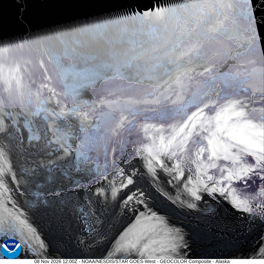
A powerful North Pacific storm is moving into the Gulf of Alaska on Monday, and the National Weather Service has posted Winter Storm Watches across a wide arc of southcentral and southeast Alaska — from Whittier and Turnagain Arm across the Kenai Peninsula to Thompson Pass, and north to the Haines and Klondike highways — warning of up to 12 inches of snow, possible blizzard conditions on the passes, and easterly gusts as high as 70 mph through Tuesday.
Source: Weatherboy — Gulf of Alaska storm report, Nov. 8, 2026
The Anchorage office of the weather service first issued its watch at 10:13 p.m. AKST on Saturday and updated it at 12:20 a.m. AKST on Sunday. It runs from Monday morning through 4 p.m. AKST on Tuesday and covers East Turnagain Arm, Portage, the Southern Kenai Mountains, the Interior Kenai Peninsula, Turnagain Pass, West Prince William Sound and Whittier — including the communities of Whittier, Moose Pass, Seward, Girdwood, Portage, Hope, Summit Lake and Chenega.
Source: Weatherboy — Gulf of Alaska storm report, Nov. 8, 2026
Snow, ice and wind along the Seward Highway corridor
Forecasters say total snow accumulations of 3 to 7 inches are possible for Whittier, eastern Turnagain Arm, Girdwood and the stretch from Moose Pass to north of Seward. The heaviest totals in the Anchorage watch area — 5 to 10 inches — are expected from Turnagain Pass to Tern Lake, including the Hope Cutoff, the high ground crossed by the Seward Highway, the main road between Anchorage and the Kenai Peninsula.
Ice is part of the threat as warmer air moves in above the surface. The watch calls for a light glaze of ice possible from Turnagain Pass to Tern Lake and up to one-tenth of an inch from the Hope Cutoff to Hope, and forecasters say snow at higher elevations may turn to a wintry mix of snow, sleet and freezing rain before changing to rain, leaving slush and standing water on roads at lower elevations.
The wind threat is focused on eastern Turnagain Arm, where the weather service says easterly winds of 55 to 70 mph are possible on Tuesday morning, peaking around 60 to 70 mph through Whittier and eastern Turnagain Arm before diminishing on Tuesday afternoon. “Travel could be very difficult,” the weather service said in the watch. “The hazardous conditions could impact the Monday evening and Tuesday morning commutes. Very strong winds could cause extensive damage to trees and power lines.”
Source: National Weather Service, Anchorage — Winter Storm Watch, via Weatherboy
Thompson Pass faces possible blizzard conditions
The same storm prompted separate Winter Storm Watches farther east in the Anchorage forecast area. For Thompson Pass, on the Richardson Highway north of Valdez, the weather service says blizzard conditions are possible from Monday morning through Tuesday afternoon, with 6 to 12 inches of snow, wind gusts as high as 45 mph and visibility as low as one-quarter mile in blowing snow. For the Ernestine zone, which includes Tonsina and 46 Mile, forecasters expect 3 to 12 inches of snow and ice accumulations from a light glaze to a few hundredths of an inch from Monday morning through Tuesday morning, with the highest totals toward the north side of Thompson Pass.
Source: Weatherboy — Gulf of Alaska storm report, Nov. 8, 2026
A second watch country: the Haines and Klondike highways
In southeast Alaska, the weather service office in Juneau has a Winter Storm Watch in effect from late tonight through late Monday night for Haines Borough and Klukwan and the Municipality of Skagway, with heavy snow possible and total accumulations of 6 to 12 inches. The watch says the upper elevations of the Haines Highway near Haines Customs and the Klondike Highway near White Pass are expected to see the highest amounts, while White Pass itself may be partly sheltered from the heaviest precipitation. Snow levels below 1,000 feet mean even lower stretches of the two highways — the freight and traveller routes linking Haines and Skagway to the Yukon — can expect accumulating snow on Monday.
Source: National Weather Service, Juneau — Winter Storm Watch (PAJK WS.A 0009)
Storm Warnings on the northern Gulf of Alaska
The marine forecast is the starkest sign of the storm's strength. The weather service has posted Storm Warnings for Monday on several northern Gulf zones: from Cape Suckling to Cape Cleare, 15 to 75 nautical miles offshore, east winds of 55 knots — about 63 mph — are forecast on Monday with seas of 22 feet building to 31 feet, and 33-foot seas on Monday night. Closer to shore, seas are expected to build from 12 to 24 feet, and Gale Warnings are in effect for inside waters including southwest Prince William Sound and Cook Inlet. The Ocean Prediction Center's 48-hour forecast chart, issued early Sunday, shows a highest value of 11 metres — about 36 feet — in the northern Gulf.
Source: Weatherboy — Gulf of Alaska storm report, Nov. 8, 2026
In its area forecast discussion issued at 3:49 p.m. AKST on Saturday, the weather service described “a strong and complex weather system” and said a North Pacific low will move into the Gulf of Alaska on Monday, “bringing gale to storm force winds to the Northern Gulf with coastal rain and inland snow.” Forecasters said model agreement points to the heaviest precipitation on Monday and Tuesday over Kodiak Island, the eastern Kenai Peninsula and Prince William Sound, with gusty winds in the usual gap locations of southcentral Alaska.
The watches cover four of Alaska's working highways: the Seward Highway along Turnagain Arm, the Richardson Highway over Thompson Pass, the Haines Highway and the Klondike Highway over White Pass. High-profile vehicles — semis, box trucks and RVs — are the most exposed in 60 to 70 mph cross-gusts, and blowing snow can cut visibility to a quarter-mile on the passes. Check Alaska 511 for road conditions before travelling, expect the watches to be upgraded to warnings or advisories as the storm nears, and plan on the worst conditions from Monday evening through Tuesday morning.
What happens next
The weather service says the watch could be upgraded or adjusted as the storm nears and urges residents to monitor the latest forecasts. Winds through Whittier and eastern Turnagain Arm are expected to diminish on Tuesday afternoon. Beyond the storm, forecasters see lingering light rain and snow along the coast on Wednesday, with another low bringing wind and rain to southcentral Alaska by Thursday. A separate National Weather Service warning for the Dalton Highway corridor in northern Alaska — a different storm area, covered by the Fairbanks office — is already in effect for Monday; this report covers only the Gulf storm watches in southcentral and southeast Alaska.