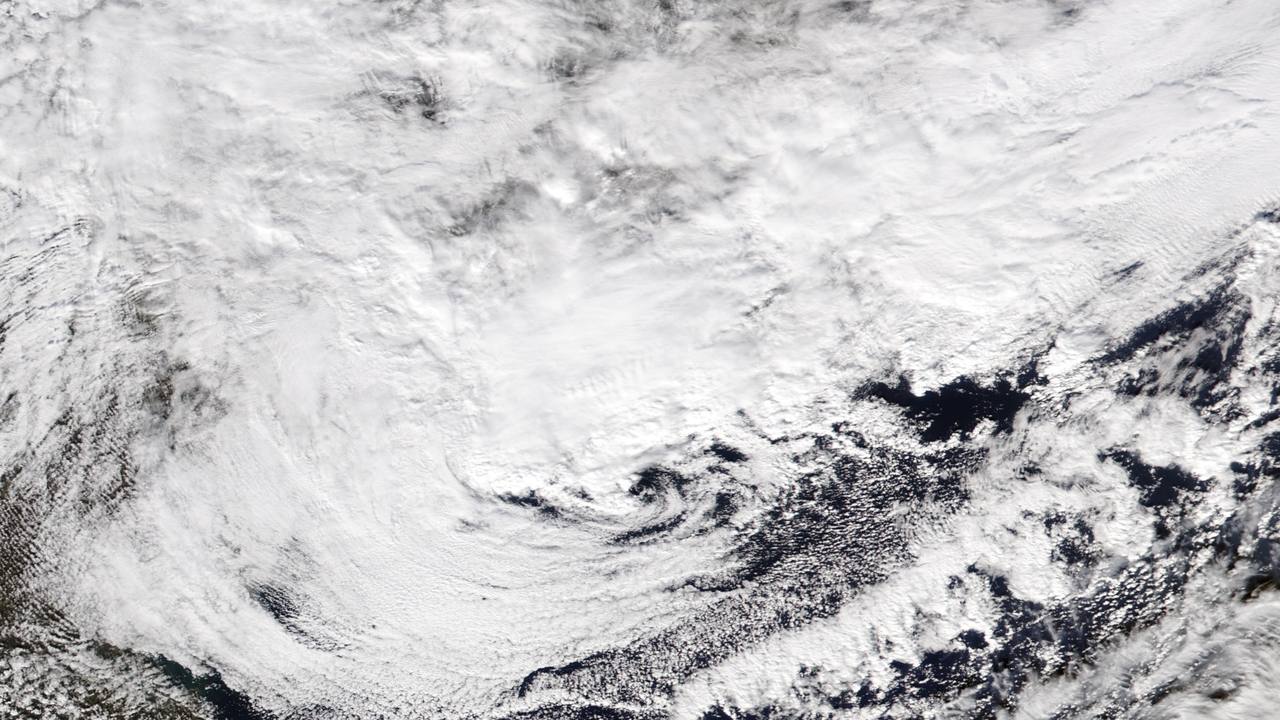
The nor'easter that formed off the U.S. Mid-Atlantic coast on Thursday, November 12, spent Friday, November 13, doing a little of everything at once to the Northeast: it dropped more than a foot of snow on parts of upstate New York, produced a confirmed tornado in Delaware, forced a rare tornado warning over New York's JFK Airport, flooded streets in Brooklyn and Queens, and ground-stopped four of the region's biggest airports. The strengthening coastal low, whose pressure fell to 992 millibars, sat just south of Long Island on Friday morning before tracking east, off Cape Cod, through the day, FOX Weather reported.
Source: FOX Weather
This is the storm Awaaz Punjab first flagged on Monday, November 9, when forecasters were still calling it only a potential late-week nor'easter with a 20-degree cold plunge behind it. The forecast has now become measured fact — records, totals and damage reports are in. Read the November 9 forecast story
A tornado warning over JFK, and a second-wettest November day
The storm's most startling moment came on Thursday afternoon, when the National Weather Service office in New York issued a tornado warning for southern Queens after radar showed rotation in a storm south of Rockaway Beach, moving northeast at 15 mph toward John F. Kennedy International Airport. Onlookers filmed a dark, rotating wall cloud near the airport; no touchdown was reported inside New York City, CBS News reported. A flash flood warning then covered southern Queens through 6:15 p.m. as the rain kept falling.
Source: National Weather Service / FOX Weather
By Thursday evening, gauges at JFK had recorded 3.04 inches of rain, and FOX Weather put the day's full total at 3.32 inches — the second-wettest November day on record at the airport. More than 1.6 inches fell in Central Park. The downpours triggered flash flooding in residential neighbourhoods of Brooklyn and Queens, forced parts of the JFK Expressway to close, and left at least one vehicle stuck in floodwaters, The Weather Channel reported.
Source: FOX Weather
New Jersey took its own round of severe weather. The National Weather Service office in Mount Holly issued two tornado warnings in the late afternoon for portions of Burlington County, southeastern Mercer County and southwestern Monmouth County, noted a rotating wall cloud observed near Westampton Township in Burlington County, and forecasters later received reports of a tornado seen on the ground in Chesterfield Township, NJ.com reported. Large accumulations of hail were reported in Bridgeport, New Jersey, and major I-95 cities including Philadelphia saw severe thunderstorms with golf-ball-sized hail, FOX Weather reported.
Source: FOX Weather
In Delaware, a tornado warning covered parts of New Castle County, including Wilmington, Newark, Stanton and Newport. A funnel cloud reported near Wilmington was later confirmed to have been a tornado, with damage reported near Christiana Hospital — only the second confirmed tornado in the state of Delaware in the month of November, The Weather Channel reported. In all, Thursday's storms generated nearly 50 storm reports from Delaware to New York, including several confirmed tornadoes, FOX Weather said.
Source: FOX Weather
The season's first big snow — and 11,000 outages upstate
Inland, the same system delivered upstate New York's first measurable snowfall of the season, and it far exceeded the roughly six inches first expected at higher elevations. The maximum reported total was 13.2 inches in Leonardsville, in Madison County. Hartwick, just south of Cooperstown, tallied 12.5 inches, Cherry Valley recorded 10 inches, and Springfield and Richfield Springs each recorded 7 inches, according to snowfall roundups by syracuse.com and the Democrat and Chronicle. The heavy, wet snow brought down lines and left nearly 11,000 customers without power across upstate New York.
Source: syracuse.com snowfall totals
Travel felt the storm on both sides of the rain-snow line. Severe weather prompted ground stops at JFK, LaGuardia, Newark Liberty International and Boston Logan International airports, delaying hundreds of flights, FOX Weather reported, and periods of heavier rain and gusty winds slowed the Friday morning commute across the Interstate 95 corridor. As the storm passed through New England on Friday it brought cold air and wind chills to Boston, gusts reached 55 to 59 mph at Block Island, Rhode Island, and the highest rainfall reported in Connecticut by Friday morning was 1.03 inches in Stamford. No deaths had been reported from the storm as of Friday evening.
Source: FOX Weather
November nor'easters usually mean cold rain for the coast and early snow inland. This one added the severe-weather ingredients of a spring storm: a tornado warning over a New York City borough, only the second confirmed November tornado in Delaware's recorded history, and a rain total at JFK that ranks second among all November days there.
What happens next
FOX Weather's forecast has the low tracking off the coast near Cape Cod and reaching peak intensity on Friday night, with the heaviest remaining snow falling from Friday afternoon into Saturday morning across upstate New York and into southern Vermont and New Hampshire. Much of the Adirondacks, the Green Mountains and the White Mountains could receive a further 1 to 3 inches, with 3 to 5 inches possible in the higher terrain of the Catskills, while valley cities such as Albany, Binghamton and Burlington see lighter amounts. New York City is expected to dry out late Friday, rain continues into Friday evening around Boston with gusts of 20 to 30 mph, and by Saturday morning most precipitation will have ended as the storm moves toward the Canadian Maritimes. These are forecasts, and totals will be updated as the storm departs.
Source: FOX Weather forecast
Behind the nor'easter, cold air sweeping across the still-warm Great Lakes switches on lake-effect snow for Friday into the weekend — a direct concern for truckers on I-90, I-94 and the Great Lakes corridors. The higher terrain of Michigan's Upper Peninsula is favoured for the heaviest snow, with more than 6 inches possible in some areas and a Winter Weather Advisory in effect for Marquette through Friday. A band off Lake Michigan could bring 1 to 3 inches to South Bend, Indiana, and more than 5 inches near Valparaiso if the band stays focused, with 1 to 3 inches also possible along western Michigan and a slushy accumulation in Chicago's southern suburbs. For the large Punjabi communities of Queens, New Jersey and the New York metro — and for diaspora travellers moving through JFK, LaGuardia and Newark this weekend — the advice from forecasters is the same as for everyone else on the corridor: expect delays, watch for black ice as temperatures fall behind the storm, and check flight and road conditions before leaving.
Source: FOX Weather