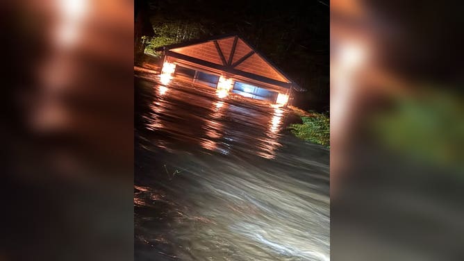
McCAYSVILLE, Georgia — A Flash Flood Emergency — the National Weather Service's rarest and most urgent flood warning — was in force for McCaysville and north central Fannin County in the north Georgia mountains early on Thursday, November 5, 2026, after torrential overnight rain sent water into homes, trapped residents and forced swiftwater rescues across Fannin and Gilmer counties along the Tennessee state line. Police in McCaysville asked people in some neighbourhoods to evacuate immediately just before 3 a.m., county officials said swiftwater rescues were under way amid widespread flooding, and the City of McCaysville declared a state of emergency just after 5 a.m., FOX Weather reported.
In a bulletin issued at 6:39 a.m. EST on Thursday, the National Weather Service in Peachtree City extended the Flash Flood Warning for north central Fannin County until 9:00 a.m. EST and kept the words 'FLASH FLOOD EMERGENCY FOR McCAYSVILLE' at the top of it. The service said Doppler radar and automated rain gauges indicated thunderstorms producing heavy rain in McCaysville, that between 3 and 5 inches of rain had fallen there, that flash flooding was already occurring, and that no additional rainfall was expected — while warning that flooding impacts would continue. The bulletin carried the NWS's highest damage tag, 'FLASH FLOOD DAMAGE THREAT... CATASTROPHIC,' and its instruction was blunt: 'This is a PARTICULARLY DANGEROUS SITUATION. SEEK HIGHER GROUND NOW!'
Rescues under way in Fannin County, with some areas still cut off
Fannin County officials said numerous residents still needed to be evacuated on Thursday morning, including some in areas emergency crews could not yet reach because of flooding and dangerous conditions, AccessNorthGA reported, citing the Fannin County Emergency Management Agency. A Georgia State Patrol helicopter was on standby to assist with aerial rescues and extractions once daylight arrived, and multiple agencies and mutual-aid resources were working to reach stranded residents and carry out evacuations. An emergency shelter remains open at the Fannin County Recreation Center, 370 Tom Boyd Road, in Blue Ridge. The county EMA warned residents, in capital letters in its own post, 'NOT LET THE RAIN STOPPING GIVE YOU A FALSE SENSE OF SECURITY' — floodwaters remain extremely dangerous and conditions can keep worsening even after the rain has stopped — and asked everyone to stay off the roads so crews can reach people who need help.
The Ocoee River surged into major flood stage as the rain fell, FOX Weather reported. In McCaysville itself, the police department urged residents and drivers early on Thursday to avoid the Blue Ridge Drive area at the bridge and at the Steel Bridge, WSB-TV reported in its live coverage, which described public access to McCaysville as blocked amid the flood warning and water rescue teams using boats on flooded streets to evacuate residents. McCaysville sits directly on the Georgia–Tennessee line — its twin town across the state border is Copperhill, Tennessee — and the same storm triggered a Flash Flood Emergency in Polk County, Tennessee, as well, FOX Weather said.
Gilmer County: homes flooded, some surrounded, emergency operations centre open
Neighbouring Gilmer County was hit at the same time. Its Emergency Management Agency reported widespread flooding with multiple homes flooded and some completely surrounded by water, swiftwater rescue teams actively conducting rescues and evacuations, and the Gilmer County Emergency Operations Center activated to coordinate the response and additional resources, AccessNorthGA reported. 'We currently have a multi-agency response underway, with mutual aid agencies assisting our local emergency personnel,' the Gilmer EMA said. 'In addition to flooding, crews have responded to multiple structure fires believed to have been caused by lightning strikes. We are asking all residents to STAY OFF THE ROADS unless absolutely necessary. If you are in a safe location, please shelter in place. If your home is threatened by rising water, move to higher ground immediately and call 911. Do not attempt to drive or walk through floodwaters.' Gilmer officials said their emergency resources were stretched thin early on Thursday by the number of incidents under way at once.
A Flash Flood Emergency is the highest level of flash flood warning the National Weather Service issues, reserved for situations where flooding is already causing, or is about to cause, catastrophic damage and a severe threat to human life. The NWS guidance attached to Thursday's warning is the same every time and it saves lives: move to higher ground now; do not attempt to travel unless you are fleeing an area subject to flooding or under an evacuation order; and 'Turn around, don't drown' when you meet a flooded road — most flood deaths occur in vehicles. Flooded roads in mountain counties like Fannin and Gilmer can hide washed-out pavement and low-water crossings that have become lethal, which is why both county EMAs told even residents who feel safe to stay off the roads on Thursday morning.
Schools closed as the mountain counties shut down for the day
The Fannin County School System cancelled school for Thursday, November 5, 2026, 'due to widespread storm damage across the county,' the system announced, adding that there would be no virtual or in-person school, that schools would be closed, and that directors, administrators and 12-month personnel should report to work at regular times only if it was safe to do so. WSB-TV's live coverage reported that schools had closed in two Georgia counties because of the flooding and road dangers. For families across Fannin and Gilmer, the closures were one more sign of a morning on which the ordinary map of the county — which roads are open, which bridges can be crossed, which homes can be reached — had to be redrawn hour by hour by emergency radio traffic.
Background: McCaysville has flooded like this before — three months ago
This is the second time in just over three months that McCaysville has declared a flood emergency. From late August 1 into August 2, 2026, flash flooding struck the same downtown, a municipal state of emergency was declared, floodwater entered the police department, the post office, businesses along the Riverwalk and several homes, Blue Ridge Drive was closed by mud, debris and standing water, and Georgia State Defense Force soldiers later deployed to help with debris removal and water distribution, according to reporting on the August event by The Watchers and the Georgia State Defense Force. City officials at the time attributed much of the downtown flooding to drainage problems associated with the State Highway 5 widening project, saying gravel and silt from the construction area had entered storm drains. Whether the same drainage issues played any role on Thursday has not been stated by any official source, and no cause beyond the extreme rainfall itself has been given for the November flooding — readers should treat the August history as context for why this small mountain city floods so fast, not as an explanation of this event.
One storm, half a country: the system now moving to the East Coast
The Fannin and Gilmer flooding came from storms that fired along the southern end of a massive cross-country storm system that moved into the East Coast through Thursday, FOX Weather reported — a system expected to have impacted more than 35 states and 120 million people by the end of the week. More than an inch of rain is possible across much of the Interstate 95 corridor, with localised amounts approaching 2–3 inches along the coast from Virginia to southeast New England; the rain continues through Friday and tapers from south to north, with rain lingering across southern New England into Saturday morning. For the Punjabi trucking community whose rigs run I-95, I-85 and I-75 through the Southeast and up the East Coast, the practical point is the one the Georgia EMAs made all morning: the dangerous hours are not only while rain is falling, but in the hours after, when mountain water is still moving downhill and flooded or damaged roads have not yet been inspected.
What happens next
The immediate timeline on Thursday ran through the 9:00 a.m. EST expiry of the extended warning for north central Fannin County, but officials were explicit that danger does not end when a warning expires: rivers and creeks fed by 5 to 8 inches of mountain rain keep rising after the rain stops, and rescues in cut-off areas were expected to continue as daylight and the State Patrol helicopter made them possible. After the water recedes, Fannin and Gilmer counties face damage assessment — homes entered by water, roads and low crossings damaged, and the state-of-emergency machinery McCaysville switched on just after 5 a.m. No deaths or injuries had been reported in the sources available at publication time, and officials had not given a count of homes flooded or people rescued; those numbers, and any extension of warnings or emergency declarations, will come from the county EMAs, the National Weather Service in Peachtree City and the Georgia Emergency Management Agency. Anyone in immediate danger in Fannin or Gilmer County should move to higher ground and call 911, and everyone else should follow the instruction repeated by both counties all morning: stay off the roads.