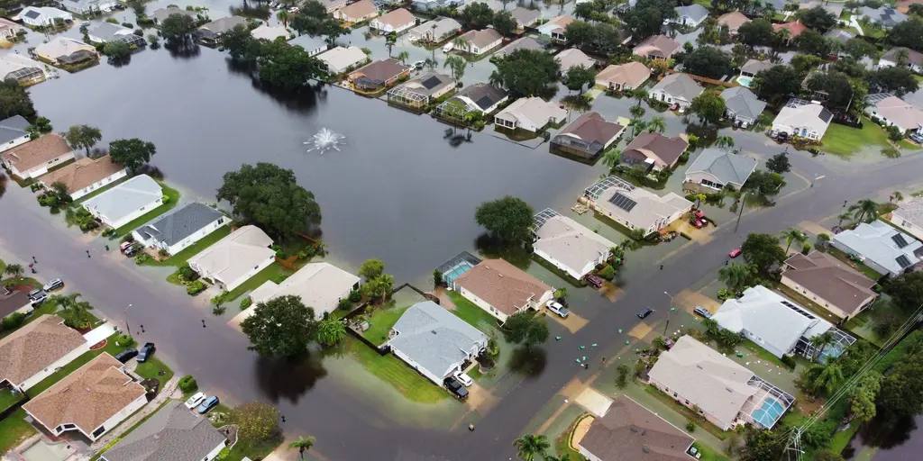
Days of torrential rain have swamped Florida's Atlantic coast, and the storm system behind it is now forecast to march up the entire East Coast this weekend — bringing heavy rain, gusty winds and coastal flooding from Georgia to New England, and threatening travel in one of the busiest weeks of the year. Forecasters say the system could even become a named tropical or subtropical storm, which would be called Kyle.
Source: CNN
Florida: a record river, rescues and an expanded emergency
The worst of the rain so far has fallen on Florida's Space Coast. Parts of Brevard County have already received as much as 10 inches of rain, with another 3 to 6 inches possible through Friday, and the National Weather Service in Melbourne has put parts of Brevard and Volusia counties under a rare Level 4 of 4 'high' risk of flooding rainfall for Friday. The St. Johns River near Cocoa reached a record 18.38 feet and was expected to rise to 18.6 feet on Friday.
Source: The Washington Post
Emergency crews have carried out dozens of water rescues as homes and roads flooded across the state's Atlantic coast. In one neighbourhood, resident Rick Addante helped the Florida Fish and Wildlife Conservation Commission evacuate his neighbour Terry, who lives alone and recently had open-heart surgery, as flash flooding surrounded the home.
Source: Fox Weather
Governor Ron DeSantis on Thursday expanded a state of emergency first declared on November 2 to include 21 counties, as the drenching pattern that began in South Florida on Tuesday night — with parts of the northern Miami metro area, including Broward County, suffering the worst flooding — refused to let up.
Source: The Washington Post
Could it become Tropical Storm Kyle?
In its 1:00 a.m. Friday outlook, the National Hurricane Center said a broad area of low pressure over southeastern Florida, the northwestern Bahamas and the adjacent waters had a 30 percent chance of becoming a subtropical or tropical cyclone within 48 hours and a 50 percent chance within seven days. The system could acquire subtropical or tropical characteristics as it moves generally northward, near or just offshore of the southeastern United States coast, through the weekend. Kyle is the next name on the Atlantic storm list.
Source: National Hurricane Center via The Watchers
Whether or not it earns a name, the Hurricane Center says the system is expected to produce strong, gusty winds, dangerous surf, rip currents and coastal flooding along portions of the southeast and mid-Atlantic coasts into early next week. The Melbourne weather office has issued a wind advisory for coastal Volusia and northern Brevard counties from 7:00 a.m. Friday to 7:00 a.m. Saturday, forecasting gusts of 35 to 40 mph, with a gale warning in effect for parts of the coastal waters and a high risk of life-threatening rip currents at area beaches. In northeast Florida, the Jacksonville office warned of flooding rain along the I-95 corridor through Saturday, breakers of 6 to 10 feet at beaches, and a coastal flood warning for Putnam County.
Source: National Hurricane Center via The Watchers
The weekend track: Georgia to New England
Forecast trends on Thursday showed the storm tracking closer to the East Coast as it moves north. The rain band is forecast to slowly shift northward from Friday night through Saturday, crossing into Georgia and the Carolinas and affecting cities such as Savannah in Georgia, Charleston and Myrtle Beach in South Carolina, and Wilmington and Cape Hatteras in North Carolina — including areas currently experiencing drought. A track closer to the coast could bring 2 to 4 inches of rain to at least some of these cities.
Source: The Washington Post
From Saturday night through Sunday, the storm will continue to march north, with its moisture streaming into the Mid-Atlantic. Places from Virginia Beach to Washington, D.C. and Baltimore will probably get soaked, with rainfall amounts of a half inch to 2 inches possible by the time the storm ends Monday morning. The storm is expected to reach the Northeast and New England later Sunday, drenching places from Philadelphia to New York and Boston with similar amounts, before clearing northern New England by Monday afternoon.
Source: The Washington Post
The timing could create travel problems during one of the busiest periods of the holiday week. Heavy rain and coastal flooding could lead to flooded roads and airport delays, particularly in coastal communities from Jacksonville, Florida, to Charleston, South Carolina — and the impacts could stretch as far north as New York City on Sunday. Travellers should check forecasts and flight status before setting out.
What this means for residents and road users
For people living along the coast, the advice from forecasters is consistent: never drive through flooded roads, stay out of the surf, and keep clear of beaches during the high surf and rip current warnings. For truckers and other road users, the I-95 corridor — the main north-south artery of the East Coast — faces flooding rain through Saturday in northeast Florida, with the wet weather then running up the coast through the weekend. CNN notes that the pattern is what forecasters expect in Florida this fall and winter as a super El Niño continues to strengthen, changing weather patterns and increasing storm chances across the Southeast.
Source: CNN
This storm has already brought record flooding to Central Florida, with the St. Johns River surging and schools closed in Brevard and Volusia counties. Read our earlier report. Read the earlier report
What happens next depends on the storm's exact track, and forecast models still show differences that will determine where the heaviest rain falls. The National Hurricane Center will update its outlook through the day, and the next milestone to watch is whether the low acquires tropical or subtropical characteristics and becomes Storm Kyle. State and local emergency officials in Florida, Georgia and the Carolinas are expected to update flood warnings and road closures as the rain band moves north.